Hurricane watch ordered for Florida as Tropical Storm Helene moves closer
Watches and warnings for Tropical Storm Helene covered nearly the entire coast of Florida on Tuesday, as some coastal areas braced for ocean surges as broad as 15 feet.
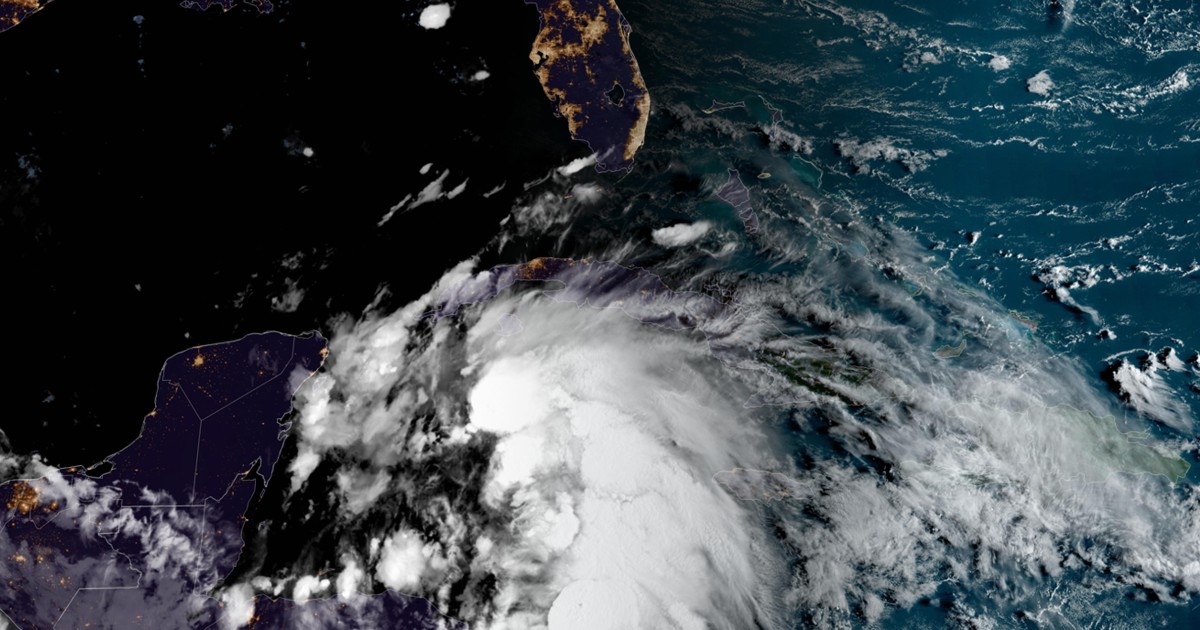
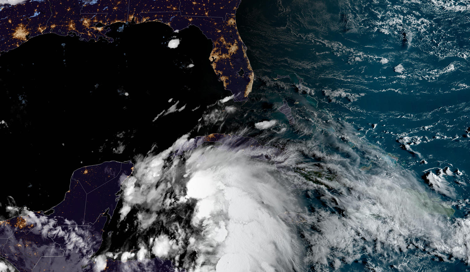
Helene officially formed Tuesday in the Caribbean Sea and was headed for the Gulf Coast, the National Hurricane Center said. The storm is forecast to strengthen into a hurricane Wednesday, and authorities urge people to prepare and exercise caution.
A hurricane warning, including possible double-digit storm surges, covered Florida’s Big Bend coast down to the state’s eastern coast at the Chassahowitzka River. The warning also means hurricane conditions, particularly damaging winds of 74 mph or greater, are imminent.
A tropical storm warning was in effect from the Chassahowitzka River south to the tip of the state, indicating that sub-hurricane winds, heavy rain and dangerous seas are imminent.
Much of the eastern coast of the state was covered by the same warning level, with the very northern stretch of coastline subject to a tropical storm warning that indicates sub-hurricane winds are likely within 48 hours.
South Florida and Miami have so far avoided watches and warnings related to the front.
At 11 p.m. ET, Helene was about 100 miles east-southeast of Cozumel, Mexico, with maximum sustained winds of 60 mph. It was moving northwest at 10 mph, according to the National Hurricane Center.
If it further strengthens, it will be the fourth hurricane to hit the U.S. this year.
The center of the storm is forecast to move across the northwestern Caribbean Sea through Tuesday night and over the eastern Gulf of Mexico on Wednesday and Thursday, the hurricane center said.
It could reach the Gulf Coast of Florida by Thursday. Helene could become a major hurricane, meaning Category 3 (with winds of 111 to 129 mph) or higher, by then.
Helene is forecast to produce 4 to 8 inches of rain over western Cuba and the Cayman Islands, with isolated totals around 12 inches. In the southeastern U.S., it’s forecast to produce 3 to 6 inches, with isolated totals around 10 inches, and it is likely to result in local flash and urban flooding. It’s also forecast to bring storm surge and strong tide, leading to flooding by rising waters’ moving inland from the shoreline, the hurricane center said.
Florida Gov. Ron DeSantis declared a state of emergency in 41 counties Monday, which was expanded to include 61 counties Tuesday. Sandbags were being distributed in Tallahassee and Gulfport ahead of potential flooding.
DeSantis said that he requested a pre-landfall emergency declaration from the Federal Emergency Management Agency and that President Joe Biden approved it Tuesday. DeSantis warned that prediction models range from showing the disturbance forming into a tropical storm to showing it exploding into a possible Category 4 major hurricane.
Models show the Big Bend and Panhandle areas should brace for potential direct impact, he said.
Jonathan Vigh, a meteorologist at the National Center for Atmospheric Research, said Monday on X that early data show “the highest probabilities are aimed at #Tallahassee, capital of #Florida, which has about a 45% chance that the center passes nearby.”
On Tuesday, he said there’s a 28% chance the storm will be a major, Category 3 hurricane when it reaches Tallahassee. The highest probability, 65%, is for the vortex to be at weaker, Category 1 strength at that point, Vigh said on X.
DeSantis urged Floridians to prepare by filling gas tanks, stocking up on food, cleaning up yards to prevent strong winds from throwing debris and being familiar with evacuation zones. So far, 18,000 line operators are ready to restore power, 3,000 National Guard personnel stand ready to assist and the Florida State Guard has also been activated, along with shallow water vessels and search-and-rescue crews.
Florida A&M University, Tallahassee State College and Florida State University have called off classes and closed campuses. Hillsborough County Public Schools, in the Tampa area, also announced schools will be closed Wednesday and Thursday.
Hillsborough County added county facilities, including libraries, parks, preserves and recreation centers to Thursday’s list of closures, according to a statement.
On the southeastern Gulf Coast, Sarasota County, Charlotte County and the city of St. Petersburg all declared local states of emergency.
The Sarasota County government said it will send out an evacuation alert for certain communities and manufactured home communities starting Wednesday morning. Charlotte County said evacuations have been ordered for barrier islands, low-lying and flood-prone areas and manufactured homes and residences that can’t withstand powerful winds. The city of St. Petersburg said mandatory evacuation orders were issued in Pinellas County for health care and long-term care facilities in certain zones.
Hernando County, north of the Tampa Bay, also called for mandatory evacuations for areas west of U.S. Highway 19 starting Wednesday morning.
Tampa General Hospital, which has the region’s only Level I trauma center, began installing an AquaFence, set to be fully in place by Wednesday. The fence provides “a water-tight barrier capable of withstanding up to 15 feet of storm surge to protect vulnerable areas of the hospital,” the hospital wrote on Facebook.
Georgia Gov. Brian Kemp also declared a state of emergency Tuesday as a southern part of the state was put under a tropical storm watch. The executive order enables first responders to better prepare for the storm, he said.
The National Hurricane Center’s forecast path has the storm moving into Georgia early Friday and over the Atlanta area by the afternoon. By then, it will have weakened from a possible major hurricane, with torrential rain as its most concerning impact, forecasters say.
National Hurricane Center Deputy Director Jamie Rhome said in a video update Tuesday that Atlanta and other parts of Georgia near the front’s projected path should be “alert for potential flooding as this system moves inland.”
The National Oceanic and Atmospheric Administration predicted an extremely active hurricane season, forecasting 17 to 24 named storms, eight to 13 of which could become hurricanes, including four to seven major hurricanes.
The hurricane season runs from June 1 through Nov. 30. The reasons for the high activity include warmer-than-average sea surface temperatures in the tropical Atlantic and Caribbean Sea, reduced vertical wind shear, weaker tropical Atlantic trade winds and an enhanced west African monsoon.
In the case of Helene, record warm waters will fuel intensification. According to Climate Central, exceptionally warm sea surface temperatures along the system’s projected path, through the northern Caribbean and the eastern Gulf of Mexico, have become at least 200 to 500 times more likely because of human-caused climate change. Rapidly intensifying hurricanes are becoming more common in the warmer world.
If Helene does become a hurricane, it will be the fifth to have made landfall in Florida in three years, according to the Florida Climate Center.